Set sail on an unforgettable journey through the breathtaking San Juan Islands, guided by expert local knowledge, detailed maps, and meticulously crafted boating itineraries. Master the rhythms of tides and currents to glide effortlessly between islands. Pitch your tent in hidden forested parks, drop anchor in pristine bays, and hike trails that lead to sweeping vistas. Wander the bustling charm of Friday Harbor and the elegance of Roche Harbor—then escape it all in a serene, secluded cove where the world slips quietly away.

++++ ============================= All Posts Below

Current Posts Below

Mar 30, 2023

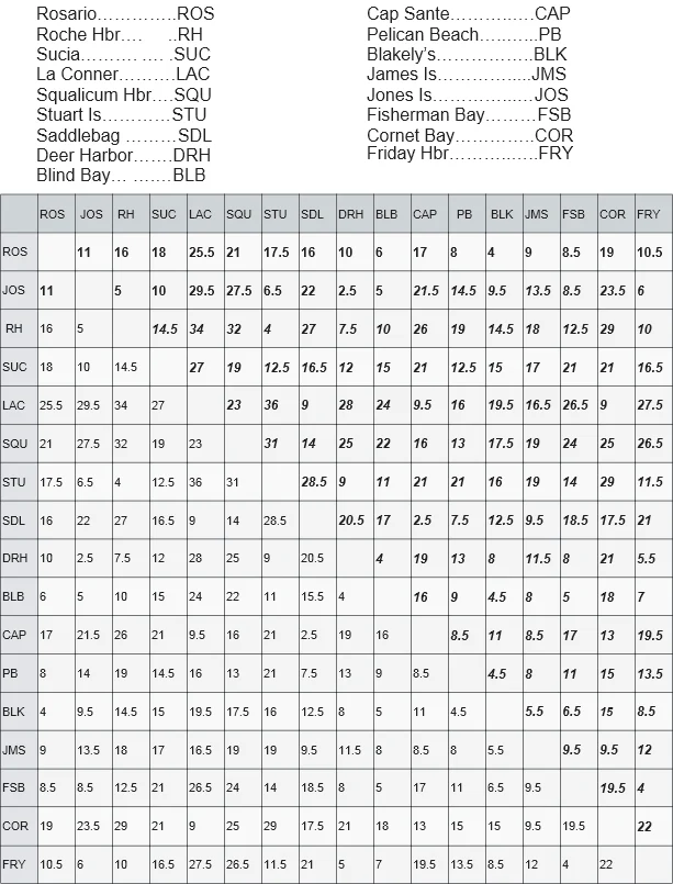
Quick distance chart from where you are to where you want to be in the San Juan Islands

   Every skipper needs to know how far it is from A to B.

      Here's a handy chart with the work already done, the distances are via the shortest route.
                                  First published 7/30/2016   

Chart showing distance in miles between the san Juan's popular stops

Note: The shortest route may not be the fastest or best route when currents and other issues are taken into account!
These numbers are approximate, and were derived by simply clicking "measure route" on a chart. Since making this chart I have come across several u-tube videos with distances that don't agree with  mine. Be sure to not rely on others and do your own calculations. 


When you are rushing from place to place, be very careful around unfamiliar surroundings so that you don't get a surprise.  The best advice is to slow down and keep watch.  Follow this link to learn of some shockers.  > Eight nasty surprises